Merthyr Pit Reclamation – Ffos-y-Fran


Ffos-y-Fran began life not as a “new” mine but as a pit reclamation scheme formally agreed in the early 2000s to heal a scarred landscape of deep mining workings on the northeast edge of Merthyr Tydfil. It became far more than that. By 2023 it had grown into the largest opencast – that is, open-pit – coal mine in the UK, extracting nearly 11 million tonnes of coal from a vast bowl etched into the hills above homes, fields and footpaths. The coal beneath these hills is part of the rich South Wales Coalfield, historically prized for its quality and the strength of the coke it produces – one reason the site was seen as viable for extraction once the land was being dug anyway.
Stepping back in time, the people who once worked in the deep pits of Merthyr Tydfil lived very different lives from the modern era. In the 19th and early 20th centuries, miners and their families lived in tight rows of terraced houses clustered close to the collieries. These houses were simple, often two-up, two-down brick or stone dwellings, with narrow streets and little in the way of gardens. The rhythms of everyday life were set by long hours underground, dirty, dangerous conditions and the constant threat of injury. Life was hard: earnings were modest, housing cramped, and communities bore the emotional and physical toll of mining disasters and illness from dust and lung disease. Although deep mining has long ceased here, that legacy shapes local memory and identity. (If you look at scattered old maps of Merthyr and Dowlais, you can still see where rows of pit houses once stood – pages of tiny rectangles marching along named streets, marked “miners’ cottages.”)
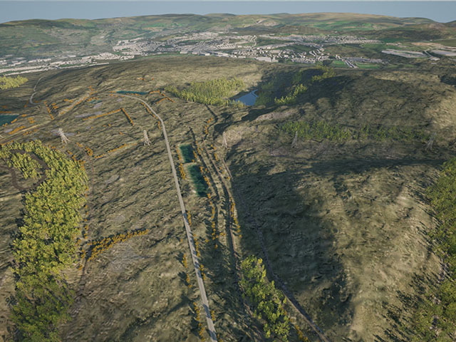
By contrast, Ffos-y-Fran was an opencast pit, not a traditional deep mine with shafts and underground galleries. Opencast mining removes soil and rock above the coal seam, creating an enormous terraced bowl in the ground, with heavy machinery scraping out overburden by the bucketful. As the pit grew over the years, its edges climbed hundreds of metres above the surrounding land, and conveyor belts, haul roads, stockpiles and tip mounds became prominent features of the skyline.
When first permitted following closure of the pit, the scheme’s backers argued that the land beneath and around Ffos-y-Fran was dangerous because of old workings and spoil heaps, and that pit reclamation it by opencast extraction would allow the whole area to be reshaped into something safer, greener and more useful. Revenues from the coal were meant to help pay for landscaping, re-contouring the hills and restoring habitats. But over time the costs of restoration ballooned and plans became controversial. Community groups pointed out that the mine operated close to homes in Merthyr Tydfil, and that ordinary protections were weakened for the sake of economic arguments.
Merthyr Pit Reclamation
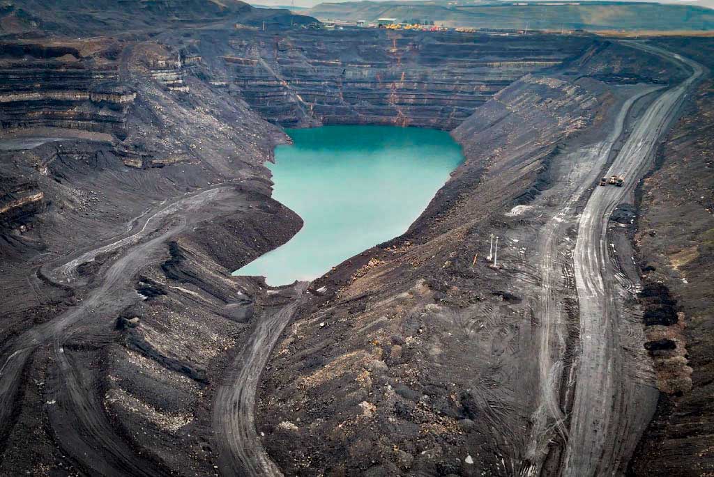
A visual impression of the current site today would show a vast, steep-sided depression hundreds of metres across. At its base, where rainwater collects, there is a large water body beginning to form, bounded on one side by sheer coal faces and on others by machines and heavy equipment no longer in full use. Around the pit rim are towering overburden mounds – the enormous piles of earth and rock stripped off to reach the coal – rising in some places almost as high as the surrounding hills once were. In the distance, the residual settlement of Merthyr climbs up the hillsides, rows of roofs and chimneys unmistakable against the skyline.
The original pit reclamation plan agreed when permission was granted envisioned a return of this land to a rolling, vegetated landscape much closer to its natural contours, with tips and overburden mounds buried back into the void and a mosaic of woodland, pasture and wildlife habitats. Crucially, that plan anticipated the entire bowl would be filled back in, tipping the soil and rocks extracted back into the excavated space so the land could be blended back into the existing hillsides. Local residents were led to expect not an artificial lake and enormous spoil tips, but gentle slopes reconnecting to ancient footpaths and grazing land.
However, the current proposed pit reclamation plan before the council and regulators differs significantly. Instead of filling the void completely, the latest application envisages leaving the pit partly open and allowing it to flood, becoming a permanent lake of up to a million cubic metres of water. Several of the tallest overburden mounds – in some cases holding tens of millions of cubic metres of spoil – would remain almost entirely above ground, altering the skyline dramatically rather than blending it back into the hills. Concerns have been raised that rainwater running down the exposed coal faces and tip sides will wash metals and other substances into the water body and downstream waterways. Opponents of the downsized plan describe it as a half-finished scar, unfinished and potentially unstable, rather than the restorative cycle originally promised.
Public anxiety has focused on the dangers posed by toxic water and steep cliffs. Because the water in a flooded pit is fed only by rain and surface runoff, its chemistry can be unpredictable: it can become acidic and mobilise metals from the exposed rock. Natural Resources Wales is monitoring the water and has stated it does not currently pose a health risk, and that the pit’s stability has been inspected by geotechnical engineers, but many local residents are still wary about long-term safety.
Another source of tension is the financing of landscaping and restoration work. In the original deal, operators were supposed to set aside funds from coal revenues to pay for the full pit reclamation. A council-held escrow account contains some £15 million, but estimates of full restoration costs run as high as £75–£125 million, meaning the current funds would cover only a fraction of what was originally promised. Campaigners and some councillors fear that if the company’s revised plan is accepted, much of the cost will fall to the public sector rather than the private operators, leaving taxpayers or local government to pick up the tab should anything go wrong.
There is also debate over the possibility of future reuse of the site. A completely restored landscape could, in theory, be used for recreational walks, wildlife reserves, limited housing or light commercial use consistent with local planning; a partly flooded bowl with towering spoil tips is less obviously adaptable, though such features could be integrated into future use plans with careful ecological and landscape design. Some campaigners argue that a water body could be an asset for wildlife if its edges are designed to encourage wetland habitats, but that would still fall short of the broad promise of returning the land to something resembling its former topography.
The saga of Ffos-y-Fran highlights how coal – once king in South Wales – still leaves legacies long after extraction ceases: not just in place names and memory, but in the very shape of the ground and in ongoing debates about who pays for environmental repair associated with pit reclamation, what counts as adequate restoration, and how communities near former pits can be secured against physical and ecological hazards.
